|
|
|
|
The Cumberland & Ohio Valley Railroad
Layout at a Glance
Name: Cumberland and Ohio Valley
Scale: HO
Size: 24 X 32
Locale: Eastern Kentucky
Op Session Periods: Rotates between late 1940's and late 1960's
Layout Height: 48 inches
Benchwork: L-Girder
Subroadbed: ½ inch plywood
Roadbed: Cork
Track: Atlas Code 83
Minimum Turnout: #6
Minimum Radius: 36 inches on Mainline
Landforms: Plaster cloth over cardboard webbing and Sculptamold
Scenery: Real dirt, ground foam, static grass, rubber rock faces
Backdrop: 1/4" Birch covered with foam core-backed commercial backdrops
Control: Digitrax Radio Super Chief
A Brief History of the C&OV Railroad
The Cumberland & Ohio Valley Railroad was incorporated on October 31, 1901, in anticipation of a merger of three Kentucky-based railroad companies; the Cumberland & Winchester (C&W), the Middlesboro & Olive Hill (M&OH), and the Kentucky & Ohio Valley (K&OV). It began formal operations on January 1, 1902 and continued to service numerous mines and industries in eastern Kentucky. The railroad was based in Colton, KY where a small yard, turntable and servicing facilities were built to accommodate the increase in traffic. As the town grew, a Union Station was built to service both the C&OV and the Chesapeake & Ohio, whose mainline also crossed through Colton. The C&OV had interchange with the L&N and Southern Railway at the southern terminus of the line, located in Middlesboro, KY. At the northern terminus of Columbus, OH, interchange occurred with the Pennsylvania, New York Central, and the N&W. There were numerous crossings with the L&N and C&O throughout the system as well.
In 1946, the Louisville and Nashville Railroad expressed interest in acquiring the C&OV trackage. However, the ICC did not approve the merger and the majority shareholders eventually sold their interest in the C&OV to the Chesapeake & Ohio in 1949. The C&O continued to operate the Cumberland & Ohio Valley as a separate entity, including its name and roster of equipment. Gradually, the two lines' services, personnel, motive power, rolling stock, and facilities were integrated. On July 2, 1968, the final C&OV locomotive was repainted in the C&O livery. This would remain unchanged until 1973 when the Chessie System was created as a holding company for the C&O, B&O and Western Maryland Railway. Forty years later, the C&O, and what remained of the original C&OV trackage, was absorbed into CSX Transportation.
Design and Construction
The layout was initially designed for continuous running of four trains on two double-track mainlines at different heights. The 4-track passenger station and 6-track freight yard would provide places for ten trains to be stored and run as desired. During the process of dismantling the old MA&G layout, I met several local guys who were very interested in operating the new layout once it was built. This ignited a renewed interest in operations, so I redesigned parts of the layout to allow room for six hidden staging yards (23 tracks total). A minimum aisle width of four feet was established, with most being five or six feet wide. Using the track plan as our guide, let's take a tour around the layout beginning at the east end town of Stanton.
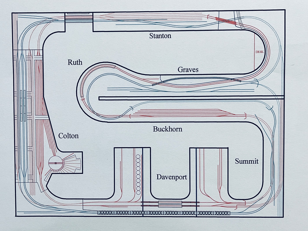
Stanton, KY is a small town with three rail-served industries (Blue Ridge Pickles, Holditch Furniture, H.W. Myers Feed and Fuel) and a depot. On the east end, an assortment of bridges crosses the Licking River that leads to the Columbus, OH staging yard. The prototype river is a tributary of the Ohio river and continues to the other side of the aisle at Graves. Hidden underneath Stanton is the four-track Ashland, KY staging yard and the lower mainline tracks that lead to the Cincinnati, OH staging yards. Both levels cross a pair of hinged lift bridges to pass in front of the door.
Colton is the largest town on the layout and represents a large city. It features a six-track yard with a turntable, 15 stall roundhouse, and servicing facilities for both steam and diesel locomotives. Also located in Colton is Union Station which has elevated passenger platforms on a 16-foot long viaduct. Two platforms service four passenger tracks for both Union Station and the adjacent Railway Express building. There are also two tracks for freight traffic, one of which serves as a set out spur for Allied Wholesale Grocers and Anderson Manufacturing. At the east end of the viaduct is the large Swift Packing Co. The facility has three separate tracks for the stock pens, the ice platform and shipping. The west end of Colton is home to Blue Star Plastics which represents a newer industry built in 1968. It has a silo track for unloading plastic pellets and an interior warehouse track for shipping. Hidden under the upper part of Colton is a five-track staging yard representing the L&N line from Lexington, KY, and a five-track storage yard for trains not used during operating sessions.
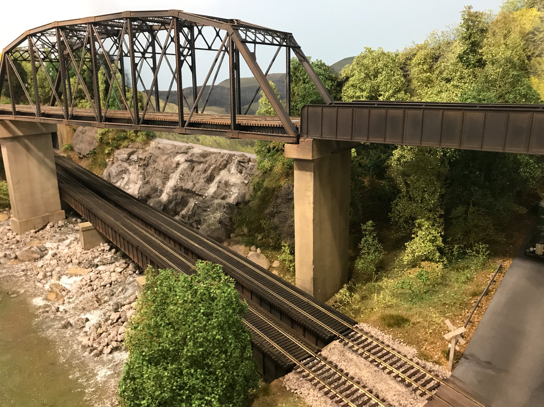
The next town westbound is Davenport, KY. Davenport is fictionally located along the western bank of the prototype Big Sandy River which is a tributary of the Ohio River. Here, the four mainline tracks cross a pair of operating Walthers bascule bridges in the front and an impressive span of eight double-track arched Pratt truss bridges near the back. A highway also crosses the river over a vertical lift bridge kit made by Custom Model Railroads. The banks of the river continue forward on two parallel 4' x 6' peninsulas. The west peninsula features the Boone Paper Mill with separate tracks for unloading of kaolin, loading of waste chemicals, a warehouse, receiving of liquid chemicals and unloading of wood chip hoppers via a rotary dump. The Bluegrass Cement Plant is located on the east peninsula. It also has five tracks for spotting cars including a holding track for inbound empties, two loading tracks, a track for unloading additives such as gypsum, and a shipping warehouse for bagged cement. Limestone is brought in by barge and transferred to a conveyor system by crane.
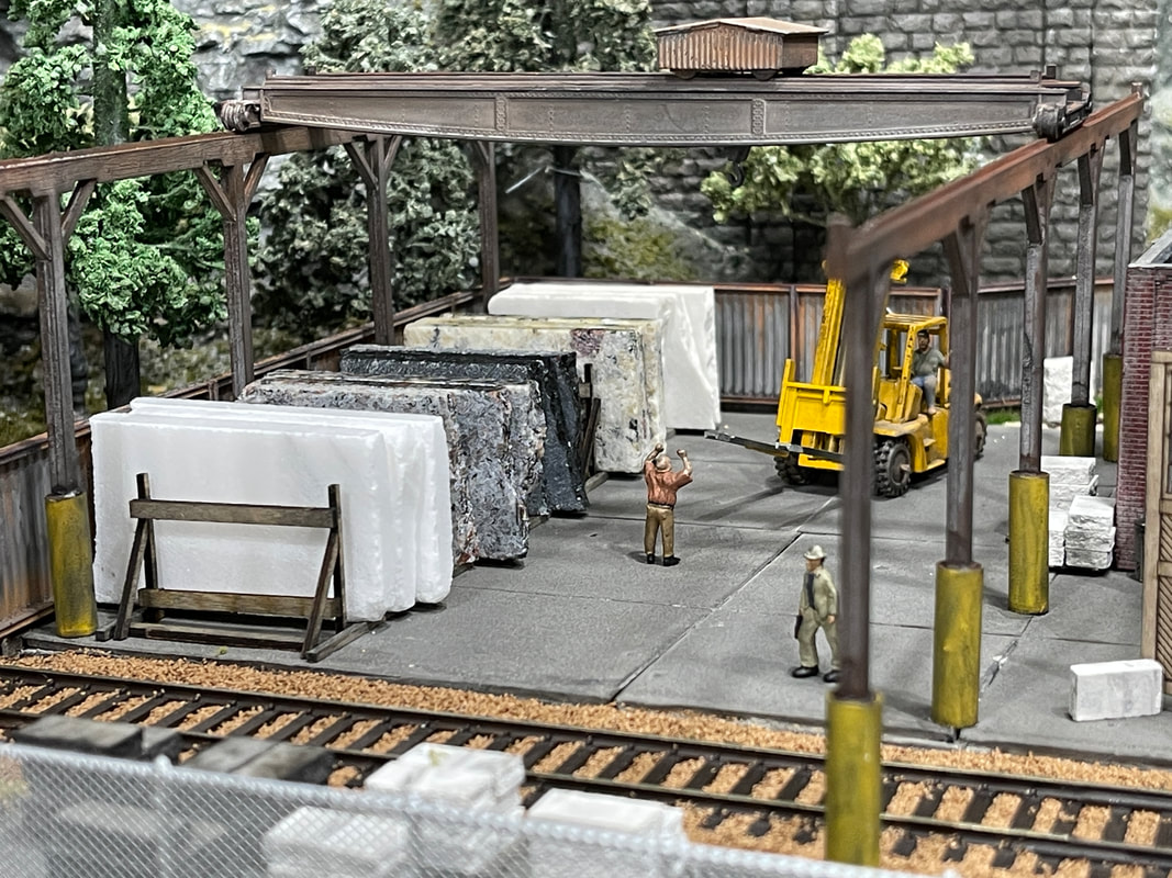
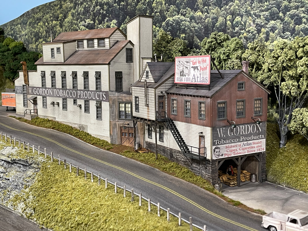
Continuing west, we next come to Summit, KY. It boasts a station, W. Gordon Tobacco Products, and four rail-served industries; the Stennis Monument Co., Mabry Paint & Stain, the J. Haggard Distillery, and a spur for pulpwood loading. The lower mainlines disappear under the town so that only the upper mainlines are visible. Also located underneath is a three-track staging yard that represents the L&N's line from Lexington, KY. Hidden behind the depot are the two upper staging yards representing Middlesboro, KY and Columbus, OH.
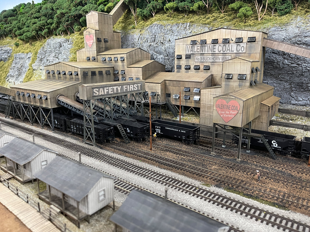
As the lower mainlines emerge from hidden track under Summit, trains enter Buckhorn, KY. Buckhorn is home to the sprawling Valentine Coal Co. Mine #3. The tipple has a capacity of 40 coal hoppers on its four tracks. A slack loader, located on the opposite side of the main line near the depot, is serviced by trucks. After passing through a tunnel, the lower mainlines curve around the original front wall of the building, supported by a massive double-track wooden trestle.
The last modeled town on the lower line is Graves, KY which is home to the Hechinger Bag & Burlap Company, the Graves depot and a small food stand. After curving around the banks of the Licking River, the lower lines cross it over twin plate girder bridges and continue under Stanton into the Cincinnati staging yard.
The upper mainlines are hidden from view behind the Valentine Mine until they emerge from a tunnel portal and curve around the small town of Ruth, KY. This area features company houses, an automotive garage, a BBQ joint, and a hotel complete with an observation deck for railfans to view the trestle below. The upper mainlines hug the edge of a sloping rock face and pass the H.B. Tubbins Lumber Co. which has three spur tracks for unloading logs, loading wood chips and a covered loading shed for lumber shipments. Further down the line, the Valentine Coal Co. has a small tipple here (Mine #2) with a lower dump house for mine carts and truck dump connected up the hill by a conveyor. Trains that pass through Ruth on the south track do so over a huge steel trestle constructed from 28 Walthers kits. The supports stand in the Licking River. Through a pair of tunnel portals at the west end of Ruth, trains can enter the Columbus, OH staging yard or take an alternate route (not used during op sessions) that allows for continuous running back to our starting point, Stanton. This connecting track, as well as the entry point to the Middlesboro staging yard, is hidden by a mountain side. A curving dirt road passes by country store and a rural church, as well as company houses for the Valentine tipple. This area is located above my desk/workbench.
Check out the galleries below to see more photos of these areas during different levels of construction. I will be updating them much more frequently as progress is made. Also, the new Operations page will share details, photos and videos related to the sequence timetable, car forwarding, dispatching, staging yard detection and my Op Sessions.
Colton is the largest town on the layout and represents a large city. It features a six-track yard with a turntable, 15 stall roundhouse, and servicing facilities for both steam and diesel locomotives. Also located in Colton is Union Station which has elevated passenger platforms on a 16-foot long viaduct. Two platforms service four passenger tracks for both Union Station and the adjacent Railway Express building. There are also two tracks for freight traffic, one of which serves as a set out spur for Allied Wholesale Grocers and Anderson Manufacturing. At the east end of the viaduct is the large Swift Packing Co. The facility has three separate tracks for the stock pens, the ice platform and shipping. The west end of Colton is home to Blue Star Plastics which represents a newer industry built in 1968. It has a silo track for unloading plastic pellets and an interior warehouse track for shipping. Hidden under the upper part of Colton is a five-track staging yard representing the L&N line from Lexington, KY, and a five-track storage yard for trains not used during operating sessions.
The next town westbound is Davenport, KY. Davenport is fictionally located along the western bank of the prototype Big Sandy River which is a tributary of the Ohio River. Here, the four mainline tracks cross a pair of operating Walthers bascule bridges in the front and an impressive span of eight double-track arched Pratt truss bridges near the back. A highway also crosses the river over a vertical lift bridge kit made by Custom Model Railroads. The banks of the river continue forward on two parallel 4' x 6' peninsulas. The west peninsula features the Boone Paper Mill with separate tracks for unloading of kaolin, loading of waste chemicals, a warehouse, receiving of liquid chemicals and unloading of wood chip hoppers via a rotary dump. The Bluegrass Cement Plant is located on the east peninsula. It also has five tracks for spotting cars including a holding track for inbound empties, two loading tracks, a track for unloading additives such as gypsum, and a shipping warehouse for bagged cement. Limestone is brought in by barge and transferred to a conveyor system by crane.
Continuing west, we next come to Summit, KY. It boasts a station, W. Gordon Tobacco Products, and four rail-served industries; the Stennis Monument Co., Mabry Paint & Stain, the J. Haggard Distillery, and a spur for pulpwood loading. The lower mainlines disappear under the town so that only the upper mainlines are visible. Also located underneath is a three-track staging yard that represents the L&N's line from Lexington, KY. Hidden behind the depot are the two upper staging yards representing Middlesboro, KY and Columbus, OH.
As the lower mainlines emerge from hidden track under Summit, trains enter Buckhorn, KY. Buckhorn is home to the sprawling Valentine Coal Co. Mine #3. The tipple has a capacity of 40 coal hoppers on its four tracks. A slack loader, located on the opposite side of the main line near the depot, is serviced by trucks. After passing through a tunnel, the lower mainlines curve around the original front wall of the building, supported by a massive double-track wooden trestle.
The last modeled town on the lower line is Graves, KY which is home to the Hechinger Bag & Burlap Company, the Graves depot and a small food stand. After curving around the banks of the Licking River, the lower lines cross it over twin plate girder bridges and continue under Stanton into the Cincinnati staging yard.
The upper mainlines are hidden from view behind the Valentine Mine until they emerge from a tunnel portal and curve around the small town of Ruth, KY. This area features company houses, an automotive garage, a BBQ joint, and a hotel complete with an observation deck for railfans to view the trestle below. The upper mainlines hug the edge of a sloping rock face and pass the H.B. Tubbins Lumber Co. which has three spur tracks for unloading logs, loading wood chips and a covered loading shed for lumber shipments. Further down the line, the Valentine Coal Co. has a small tipple here (Mine #2) with a lower dump house for mine carts and truck dump connected up the hill by a conveyor. Trains that pass through Ruth on the south track do so over a huge steel trestle constructed from 28 Walthers kits. The supports stand in the Licking River. Through a pair of tunnel portals at the west end of Ruth, trains can enter the Columbus, OH staging yard or take an alternate route (not used during op sessions) that allows for continuous running back to our starting point, Stanton. This connecting track, as well as the entry point to the Middlesboro staging yard, is hidden by a mountain side. A curving dirt road passes by country store and a rural church, as well as company houses for the Valentine tipple. This area is located above my desk/workbench.
Check out the galleries below to see more photos of these areas during different levels of construction. I will be updating them much more frequently as progress is made. Also, the new Operations page will share details, photos and videos related to the sequence timetable, car forwarding, dispatching, staging yard detection and my Op Sessions.